Yes the prodigal blogger has returned and yes I am typing this (most likely the next to last blog post) on my laptop whose comma key doesn't function. I apologize for my long absence I have just been so busy doing nothing for the last week and a half that I have put off writing this post. Not walking 17 miles a day and getting literally tens of decent nights of sleep is really taking its toll. My knees no longer feel as though they are being attacked by a thousand vice grips and I no longer awaken at 5:30 am covered in sweat snow rain dust or dirt...because now I live indoors...not in a shelter. I'm getting ahead of myself.
Before I go into a little more detail about the completion of my journey there are a few people who deserve some thanks and I apologize for its lateness. I'd like to thank the Pietruchas who graciously offered to take Earl Grey and I into there home (via a most excellent sign displaying the deathly hallows) in Bennington VT. Had we not already accepted an invitation to spend the night at Sandman's house we would have no doubt accepted the offer of a shower and bed. I'd also like to thank Sandman for inviting us to his parents house and Wingmom for making our stay there so amazing. I had an awesome time eating some good food and getting some good sleep!
A huge special thanks to the Taylors. "Thanks" doesn't seem like enough. They gave us a place to sleep and rides back to the AT (allowing us to slack pack through some difficult terrain) for 3 nights! The food was terrific and the company even better. They helped to make Maine one of my favorite states. It was so nice to see Linda and John and Caleb after so many years! It really was great just to have some down time to sit in a comfortable chair and watch some movies.
You may assume that once we crossed the state line into Maine that it was all smooth sailing or that we were "almost done" as we heard southbounders so often say. Neither of these assumptions are true. In my opinion the most difficult portion of the Trail began with the beginning of Maine and didn't abate until approximately 230 miles later. There are about 290 miles of the AT in Maine and while that doesn't seem like much in a 2200 mile trek it is still a significant distance. We were "close" in a sense but also frustratingly far away. With the rough terrain the going was a bit slow which added significantly to the frustration. The slower pace had advantages though. It gave us more time to observe the spectacular landscape. Maine was a truly breathtaking land of vast lakes and rugged mountains.
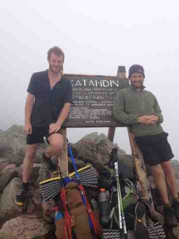
The rest of Maine pales in comparison to my first real view of Katahdin. We walked so far for so long and Katahdin always seemed like a slightly unobtainable goal. Actually seeing it was indescribable. The next day after seeing Katahdin for the first time an even better closer vista came into view whilst crossing Abol Bridge just 9 miles from that "unobtainable" goal. Now the end was really in sight. We hiked 33.1 miles to stay at a shelter called The Birches nestled nearly at the foot of Katahdin. A 5 mile hike up the most difficult and technical mountain climb awaited us the next morning. The time passed so quickly for me. Before it seemed we had scarecely started the climb with Oz and Carjacker the fog was lifted and we could see the sign along with Sconnie Chinstrap Biscuits & Gravy and Lorax. It was such a relief to finally reach the northern terminus of the Appalachian Trail. We stayed at the summit for a long while celebrating with friends and reveling in our momentous accomplishment.
I'd like to thank my parents again who sent me care packages frequently and kept me encouraged the whole way. If any of you reading this blog have any questions about my experience on the Trail or about the AT in general don't hesitate to message me on Facebook or ask me in person. Oh and yes...I did JUST NOW unpack my backpack :)
Friday, August 16, 2013
Tuesday, July 30, 2013
Katahdin!
We are done. As I type we are headed home in a rental car with fellow hiker Oz after summiting on July 29. We did the 100 mile wilderness in 4.5 days over just a few mountains and mostly flat terrain. It only rained once and it was easily some of the most beautiful trail we've seen. A few days before summiting the only mountain we could see was Katahdin as we meandered along ponds and forded rivers. We also hiked our longest day ever the day before we finished, 33.1 miles.


 Our 1st view of Katahdin

 Katahdin early in the morning (up hiking at 5:30)
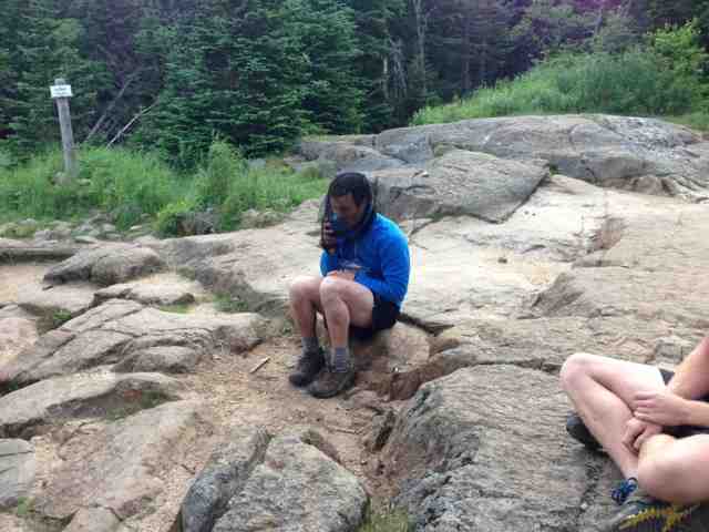
 Before heading up the big K


 Everyone who summited behind a big rock to keep out if the wind.
 Katahdin's tableland completely above the clouds.

 Before heading down the steep part of Katahdin.


 The sonic we're road tripping home in
 Thank you to everyone!
The day before we summited my parents met us at Abol Bridge and had lunch with us. We then spent the night at the birches, the final shelter and dedicated for long distance hikers. The next day we met my parents and began the misty and slightly wet climb up Katahdin. It was completely in the clouds. Although at the time this was extremely disappointing the feeling of finality was still superior. After a long 3 hour climb (it was the most difficult climb and descent of the trail) we were finally done. We hiked up with Oz and Carjacker and met everyone else who summited up there: Lorax, Biscuits and Gravy, Sconnie, Chinstrap, and Patches. It was great to be done but it was difficult for the finality to sink in, especially with a 5 mile climb down.
After much rejoicing and pictures we finally began our descent and the sun miraculously came out and I took as many pictures as I could before we went below the sky.
The climb up pretty much sheer rock
And so our journey ends! The one thing we were totally surprised by on this journey was the generosity. Thanks to all my friends like Nathan and Alex, Sam, and everyone who mailed me encouraging letters. Big thanks to everyone who mailed us food: bob and addy, the reeds, and Bethany. Bigger thanks to our families who did both the above and are probably the biggest followers if the blog: mom, dad, uncle bob, aunt sherry, grandma and grandpa Colby, grandpa Latham (thanks for the gift at the end of the trip grandpa!), and everyone else. (Also thanks to all the Ewings, but I'll let Garfunkel take care of those thanks). And our biggest thanks to everyone who took 2 dirty, smelly, and ravenous hikers into their homes and fed us, let us get clean, and sleep on their clean furniture. Deb Crissinger, Wingmom, and the Taylors, you are trail angels.
If anyone has any questions about hiking or if you're a hiker I met on the trail and want to keep in touch ask for my email in the comments and I'll get it to you ASAP.
Wednesday, July 24, 2013
100 Mile Wilderness and Katahdin
I must be quick because our shuttle is leaving soon, but we just spent the night in Monson Maine at the Lakeshore House Hostel. It was a great night and pretty much everyone we've been hiking around was here. This is the last trail town, so it was a bit of a party.


We're about to hit the 100 mile wilderness and immediately after is Katahdin, so we're planning on submitting the 29.
I have to be faster so enjoy the pictures. Next post and I'll be done!
P.S. thanks again to the Taylor's for putting us up and feeding us, it was great!
Wednesday, July 17, 2013
The Whites and Maine at last
After Hanover we had some reasonable terrain and continued mud. We came across one final and excellent iteration of Wingmom trail magic by the first grassy field in weeks. We pushed on to the Glencliff Hiker hostel in New Hampshire before starting the White Mountains which are the scariest part of the trail. The ups are the longest and steepest of the trail, incredibly rocky, and often above treeline. After doing Moosiluake and Kinsman mountains we stopped in a little known (which actually means nicer) hostel in Lincoln before starting the really difficult and gorgeous parts of the whites.
We started over Franconia ridge. I got exactly 0 views but Garfunkel, only 5 or 10 minutes behind me, got incredible views as the clouds passed away. We then hiked over Garfield (the hike down is literally a waterfall) and had lunch at one of the best spots on the trail.
Through the whites there are few shelters and campsites but there are a system of huts maintained by the Appalachian Mountain Club (AMC). The huts are large lodges run by croos ( the spelling is correct) of kids our age who cook and run the hut. A few thru hikers are allowed to stay at each hut every night and ear left overs in exchange for an hour or so of work. We stayed at Mizpah, Madison, and Carter Notch huts in exchange for scrubbing floors, scouring greasy dishes, and cleaning a dank basement. I had heard the hut system can be terrible for some hikers but we think they were one of the best parts if our hike so far. The croos were awesome due in no small part to them playing settlers of Catan with us at Mizpah and Carter.
After a few idyllic days the rain came so we had no views on Washington or after in the whites. Since most of the trail in rocky and steep I also took 5 or 6 nice falls. The hiking through the Whites as fellow hiker Oz describes it, is as close to rock climbing as you can get and still call it hiking.
We zeroed at the White Mountains Hostel and Lodge in Gorham as we hadn't in ages and it was the nicest hostel we've come across. Here we parted ways perhaps for the last time with longtime trail friend Sandman. We hiked with him through most of the Whites but he recently got off for a wedding so we likely will not see him again. We also ran into Oz, Patch, and Sophie again whom we haven't seen since heading up Franconia. We got a little separated but will likely meet up with them again in the next day or two.
After Gorham we started the Mahoosuc range and entered Maine. The Mahoosucs were just as hard as the whites with intense rock scrambles up and downhill and many spots with rebar drilled into the rock to help us. Our pace really dropped here (2 10 mile days). The weather did clear up and has been hot ever since so we've been swimming a few times. We also did the Mahoosuc Notch which is the hardest mile of the AT. It is all boulders you must go over and under. The notch is so rocky and steep under most boulders ice and snow was still hanging around on a 90 degree day in July. The guy in the later pictures is Carjacker, who we've been hiking with since we left Gorham.


Moosilauke on July 4th with patch, Sophie, Oz, and Garfunkel


This could possibly be the final blog update until Katahdin! ( we'll try for one more before summit pictures though)
Subscribe to:
Posts (Atom)